Most of this trip report highlights the challenging sections of the trail. I would like everyone to know that I had a TON of fun in this endeavor. Most of the day was spent laughing, exchanging stories, and dancing to one of the many musicals I listened to. Doing a supported effort is so enjoyable because you get to hang out and talk with friends all day long. Overall, I wouldn’t trade anything for this experience, and I am grateful I could do this with such a supportive group of people. I couldn’t have done any of this without Ben, Josh, and Zane. The best crew a girl could ask for.
Day 0 (8/16/23): 60 miles

After a few pictures and any last worries, I set off from the Waterton Canyon trailhead at 5:00am on the dot and began the flat dirt road that begins the Colorado Trail. Our emotions were a mix of excitement, confusion, and nervous energy as we embarked on this adventure. We passed the spot where my backpack had torn the previous day, and I felt thankful for opting for a supported attempt rather than going unsupported. Within a few hours, we reached the Platte River, where Zane and Josh were set up with hot coffee and hashbrowns. I took a brief break and then continued into the heat with Zane. We navigated through the burn zone, catching up on summer stories, and time seemed to pass quickly. Our next stop was more efficient, as we were all still figuring out the logistics of the supported attempt. Ben and I made good progress through the next section, occasionally sharing the trail with fast-moving mountain bikers.
Around 7:00 pm, the sky suddenly became overcast, and rain and hail poured down. We persevered through this challenging weather for an hour, with our shoes and socks drenched and our hands growing increasingly cold. After the sky cleared and the sun set, I became progressively colder to the point where I couldn't feel my hands or feet. We sent an inReach message to Ben, who quickly hiked up from the next road crossing, saving the day with a pair of sweatpants, a fleece, and a beanie. This marked the longest distance I had ever walked in a single day, and I honestly had doubts about my ability to complete it. We paused for a quick dinner, switched off with Josh for a few more miles, and eventually set up camp around mile 60 at approximately 11:30 PM. As I went to bed that night, I wondered if I would even be able to move come morning.
Day 1 (8/17/23): 57 miles + 1extra
Josh woke me up at 4:20, I quickly taped my feet, put on my socks and shoes, and began my funny tin-man walk down the trail. It took me 10 minutes of a slow, awkward walk in the morning before my body loosened up, and I moved in a regular stride. As a surprise to myself, I woke up feeling somewhat refreshed and rested from the 4.5 hours of sleep. Five miles into the morning, we met the crew at the Long Gulch Trailhead. I gulped down some breakfast, changed my socks, and was off for the morning with Zane. Right around Kenosha pass, we passed a coworker of mine, Miron, who was racing the Colorado Trail Bike Race. It was fun to see a familiar pace and see him pushing his body to the fullest in the same way I was.
At the parking lot, a nice hiker gave me a sweet tea and some watermelon, giving me energy for the next few hours. After climbing up Georgia Pass, I started feeling sleepy for the first time. I lied down for a quick one minute break then we listened to some music to get my energy back up. We joked that it only rained when I walked with Zane, which stayed true as it started to drizzle around 5:00pm as we walked into Breckenridge. I was feeling tired and slow and stopped only for a quick break to prepare for the long climb up Kokomo pass. I started having trouble eating and Ben and I struggled up slowly before reaching the top at 10:15pm. I proceeded to throw up at the top of the pass and made a phone call to my mom and a few friends as we stumbled along the ridge. We cut the day short at 57 miles in and I went to sleep feeling pretty awful after throwing up water and pepto bismol and not being able to eat dinner.
Day 2 (8/18/23): 53 miles

I “slept in” and started hiking at 4:55am, moving my way down to Copper and walking through the town on the 3 mile detour. I was still having trouble eating and it took me almost two hours to eat a biscoff cookie. Finally, at Camp Hale, I got my appetite back and downed some quesadillas and cooked ham and a cup of coffee with the crew. There was an excellent cloud cover that provided the perfect temperature for hiking as we moved up to Tennessee Pass. Honestly this day flew by and I felt great and eating good until a mile before the Timberline Lake Trail when my stomach turned. For a few miles I decided that my running vest felt too heavy to carry so Ben strapped it to the back of his pack and we chuckled as we moved along the trail. I met Bjorn at this road to do the next section until the North Half Moon trailhead. The Leadville 100 was happening the following day which was exciting as we followed the red flagging along the route. I struggled up the Powerline climb, pausing to throw up every once in a while. I passed the trail junction that borders where I live in Leadville, only 2 miles from the trail I knew my bed and the comforts of home sat. This marked a good checkpoint as I was familiar with this section and knew that once I made it past “home” I couldn’t go back. I got to the road at 10:45pm with plans to push on but began throwing up my dinner and decided I couldn’t go any farther. We set up camp early and I went to bed unable to hold anything down, hoping I would feel better in the morning.
Day 3 (8/19/23): 55.5 miles

Feeling slightly better and wanting to reset my sleep schedule to start earlier and finish earlier, I hit the trail at 3:30 a.m. and booked it down the trail wrapping around Mt. Elbert. I walked the first 1.5 hours by myself as Zane frantically tried to catch up, suspecting I was hiding in bush or had veered off toward Leadville. After breakfast at Twin Lakes, we met up with Josh’s friend Yiran, who drove out from Boulder to join ur for the day. Yiran is an accomplished hiker/scrambler/climber who had lots of cool stories to share, passing the time and miles easily. We chatted all day long and my stomach had finally settled, allowing me to consistently eat and stay hydrated.
After the Mt. Princeton climb and descent, we did a “moving dinner” where I ate part of a Philly Cheesesteak from Buena Vista and udon noodle soup. I felt great for most of the day and we set up camp around 10:50 not even feeling exhausted or hurt. My body was gradually adapting to the challenges, and I was beginning to find my rhythm.
Day 4 (8/20/23): 57 miles
I woke up this morning feeling pretty sleepy and put in some music as we powered down the road to Mt. Princeton. We made up quite a bit of time and stopped for a quick breakfast and changed my socks before setting off for a longer section with Yiran. The trail was cruisy and easy and flew by again as Yiran and I shared stories. We ran into an older hiker in his sixties who walked with us for a little under an hour. He was a farmer from Iowa who travels to Colorado almost every year to hike, usually the fourteeners.
We reached to Monarch Pass in the heat of the day, meeting up with Ben at the best aid station ever. He had set out peaches, watermelon, a baguette from Buena Vista, udon noodles, and pickles. I ate everything he had prepared, then we set off for the long climb up to Marshall Pass. We had a goofy time spent listening to music and Ben reminiscing about his earlier summer hike along this section of the CDT. Josh, Ben, and I all camped together at the Sergeant Mesa Trailhead around 11:30 to make 57 miles for the day. Once again, I went to bed without feeling exhausted and found myself excited for the day to come. My body finally felt like it was accustomed to what I was putting it through and accepted the fact that I was not going to quit.
Day 5 (8/21/23): 56.5 miles
Ben and I started down the trail around 3:30 am, only to have my headlamp and my phone die a mile down the trail. We stopped and searched through the pacer bag and couldn’t locate a charger or a backup headlamp, so we ended up comically walking next to each other, sharing the light for the next few hours until the sun rose. It was a chilly morning, and we passed quite a few tents at the one water source in the early hours of the day. We got to the first stop a little over 21 miles into the morning and refilled water and food.
Zane had left for a few days to go to his first day of school at Western Colorado University, so we were down to a two-person crew. Josh and Ben needed to work out the logistics for the next leg, so I decide to walk on my own. Fortunately, 45 minutes into the hot dirt road walk, I looked behind me to see Josh sprinting to catch up. These miles were hot, exposed, and a bit tedious, but we made up a lot of time by moving quickly. I was having an emotional afternoon and got frustrated when we had to take our shoes off to cross Cochatopa creek, as the bridge was washed out. However, I was thankful that Ben insisted I didn’t cross in my shoes and socks, as my feet dried quickly once I put my shoes back on.
Josh and I began the night section, setting up camp right before San Luis PAss around 10:30 pm. I had trouble eating dinner, not because of my stomach but because of a weird tongue infection that was making everything taste sour and dry.

Day 6 (8/22/23): 53 miles
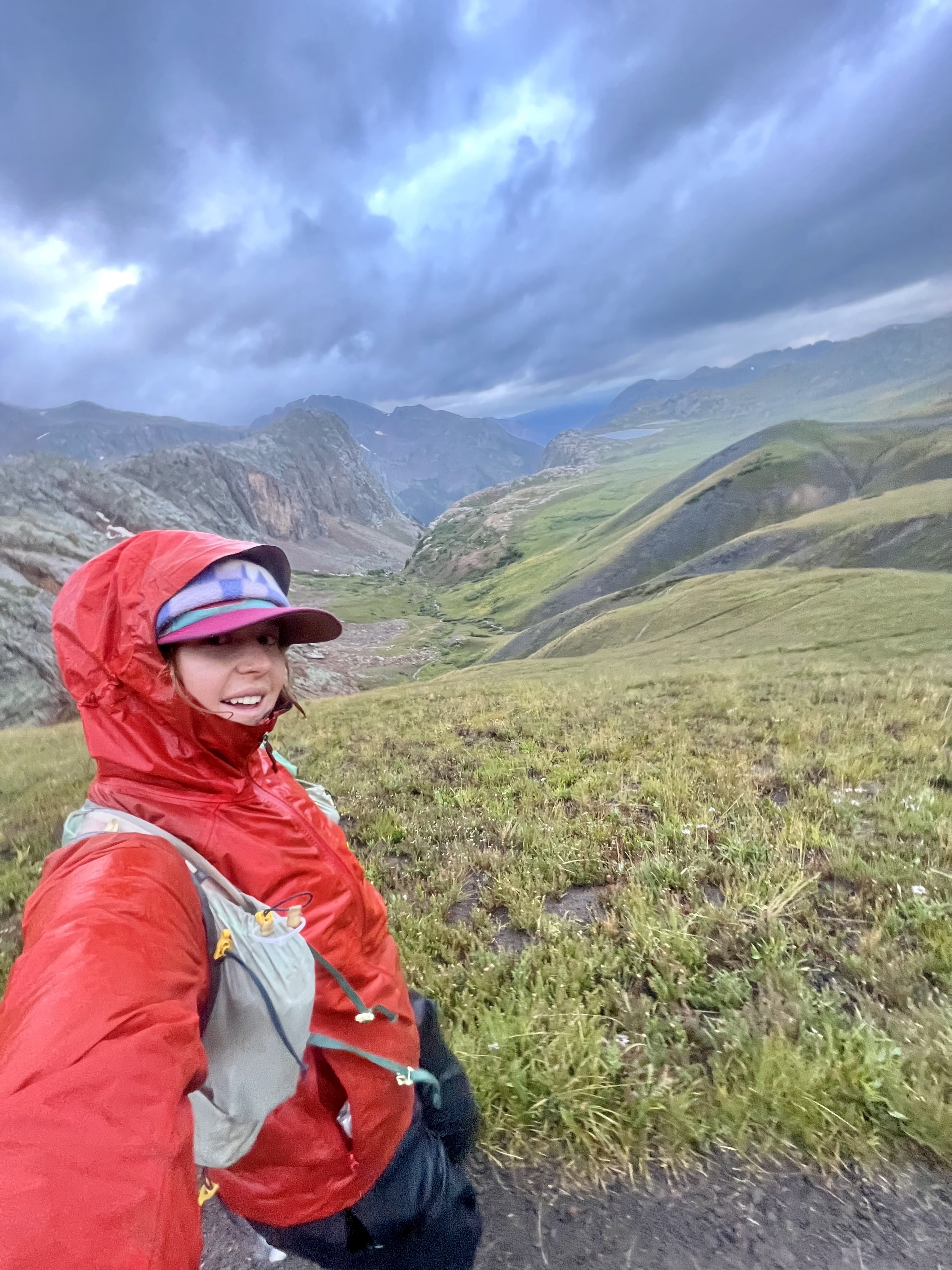
This was the first day that I didn’t manage get a restful night of sleep, and I certainly felt it. When the alarm went off, I asked Josh to let me snooze for an extra 20 minutes, then decided that any more sleep probably wouldn’t make much of a difference, so we begrudgingly got moving. We made it over San Luis Pass as it began to drizzle, setting up for a dreary and wet morning. I struggled, feeling sluggish while ascending passes and anxiously scanning the sky for signs of lightning, Even though we hadn’t heard any thunder, the ominous clouds kept me on edge. This was the first morning where I started having pain in one of my feet, feeling fine on uphills but hunting with the impact on the downhill.
After what felt like an eternity going through endless high alpine tundra, we finally reached Spring Creek Pass, where Ben was witing with some town breakfast and an assortment of snacks. I sat in the car to avoid the rain and ate whatever snacks I could while Ben and Josh figured out the logistics for the next section. It took 40 minutes, over twice as long as any break I had taken thus far, before I mustered up the strength to continue, feeling rather woozy and light-headed.
I caught up with two fellow hikers on the CT and had a pleasant chat with them. One of them even handed me $20 to buy myself a bear at the end, which gave me a much-needed confidence boost as I forged ahead while Ben hung back to chat with them. The rain came and as we reached the trail’s high point. It appeared as though it was raining and thundering everywhere except directly over us. Ben and I continued on in the afternoon and saw a double rainbow pass right at golden hour. We listened to music and joyfully romped through the San Juans, making for a truly lovely evening.
Around 9:30 pm, I started feeling sleepy and noticed my vision struggling to focus on the traiI I asked Ben for a brief nap, taking two five-minute breaks before ultimately deciding I didn’t have the energy to cover the next 6 miles to where Josh had set up camp at Stony Pass. We set up the tarp and emergency bivy Ben had packed and took a much-needed 2-hour nap before hiking the remaining miles. Thankfully, it rained the entire time we were in the bivy, stopping right around midnight when we started hiking again. It happened to be Ben’s birthday, and it felt really silly to be walking through the San Juans in the middle of the night. Eventually, we reached Josh and crawled into bed just after 2:30 a.m.
Day 7 (8/23/23): 55 miles
I left camp just after 4:00 a.m. when it started pouring rain for the first section of the trail I was doing by myself. Within minutes of starting my day, I reached into my running vest only to realize that I had forgotten almost all of the snacks I had intended to bring. Wrapped in all of my layers, I trudged through the water-filled trail, my clothes soaking through and my stomach grumbling with hunger. I couldn’t help but feel small amidst the early morning light, surrounded by towering mountains in low-hanging clouds, devoid of any human presence.
The skies cleared as I flew down the long descent to the Animas River, allowing me to make up some of the lost time from the cold, damp start. Finally reaching Molas Pass, I scarfed down a bowl of udon noodles, coffee, oatmeal, and peanut butter cups. We headed out with 75 miles to go for a beautiful section through the San Juans (not sure where because, honestly, I had no concept of what was around me or names of passes or anything). The day was relatively crusiy until just before Bolam Pass when the rain returned. Josh rushed ahead to help Ben prepare for the last aid station. I ate a decent-sized dinner at Bolam Pass, and we packed a ton of warm layers and sleep stuff,unsure of what the night would bring in terms of weather and how far I would be bale to walk.
Shortly after leaving Bolam Pass, my stomach churned, and everything I had eaten the last few hours came back up. I pressed on, listening to a podcast while ascending Blackhawk pass, feeling invigorated on the descent and ready to continue into the night. However, right before we were passing the salt water for a while, Ben tripped and hurt his ankle quite badly. After a brief pause, we decided to hike a few more miles and set up camp for a short rest. I couldn’t keep anything down and went to bed feeling terrible, but I held onto my excitement for the last day and hoped Ben’s ankle would improve by morning.
Day 8 (8/24/23): 41 miles

I awoke to the beeping of my alarm and the sound of rain pelting the tent at 2:30 a.m., feeling utterly miserable and far too weak to even contemplate moving. We snoozed the alarm for twenty minutes, then another twenty, and then another hour as I conceded that I simply couldn't muster the energy to get up. Finally, around 4:45 a.m., Ben snapped out of his own sleep-induced trance and ushered me out of the tent. He had been in a similar daze, with no recollection of waking up and hitting the snooze button. This was the first day that my body flatly refused to cooperate. It felt as if it had decided it wanted nothing to do with hiking, and I knew I'd have to will myself to the finish line.
I threw up my entire breakfast and periodically asked, then begged Ben for dirt naps all throughout the rainy morning. He was a trooper and decided to carry my backpack in addition to his and pushed me through this section until I was finally began to feel better around midday. We met Zane, proudly blowing a horn, signaling twenty miles to go and flew down the last big downhill. I was finally eating again and downed a burrito, smoothie, a banana and some peach rings.
I kept waiting for a surge of adrenaline that usually comes when you know you’re nearing the finish line, but it never arrived. We took a short two-minute break at the bottom of the last uphill, hoping it would reinvigorate me, but I threw everything up again with 13 miles to go. I was questioning if I was going to make it, feeling like I was going to pass out. We powered up the last hill as the rain soaked our layers inside out and our shoes filled with water. Once I was at the summit, I knew I could make it. We cranked up the music music and I called my Dad, who was up late into the night in Switzerland watching my tracker, for some last minute motivation.
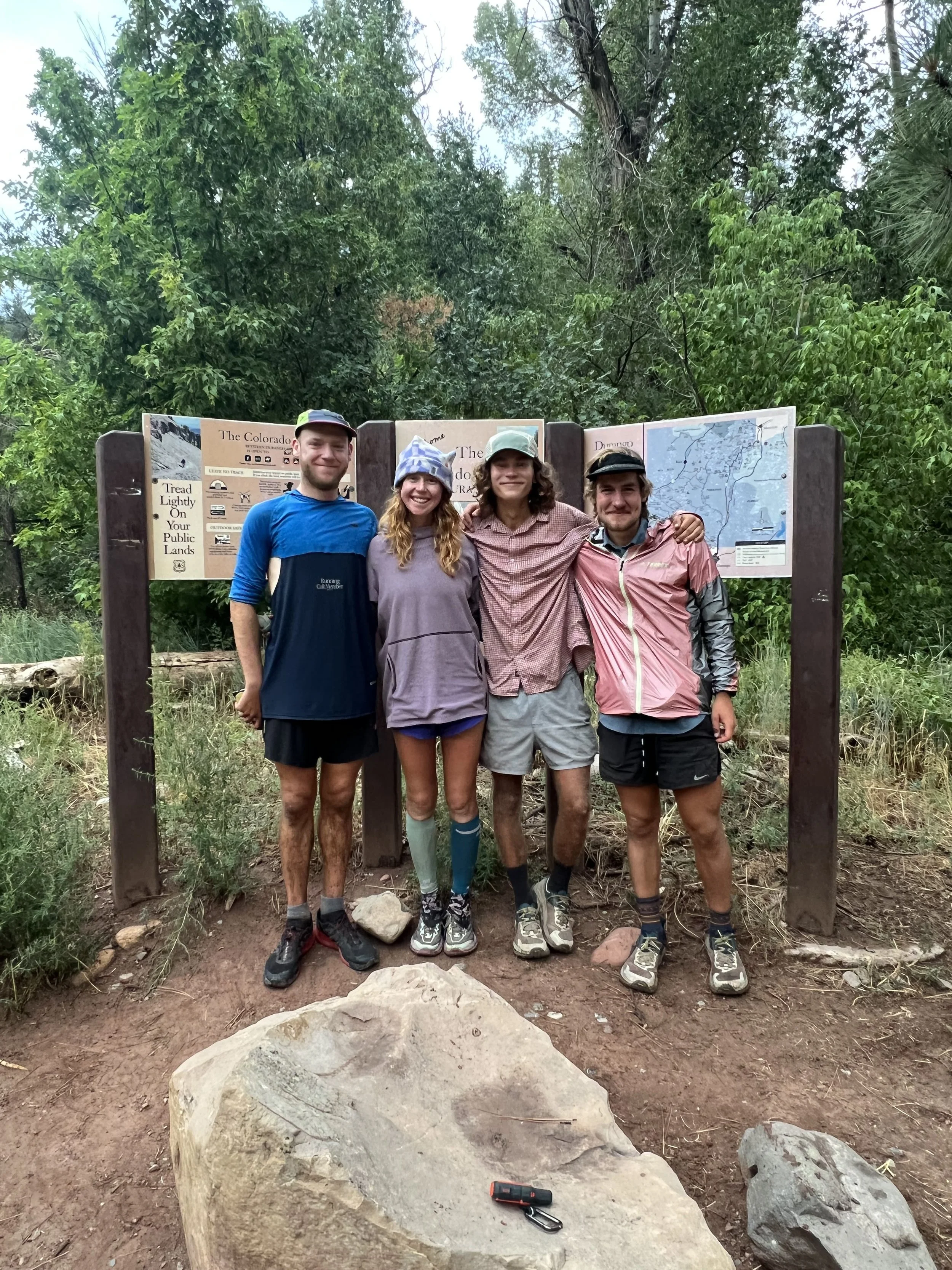
After what felt like the longest day ever, we spotted Ben and Josh hiking up the trail to meet us for the last mile. Together, we reached the terminus at 7:15 pm, finishing the Colorado Trail in 8 days 14 hours and 15 minutes, setting a new womens supported record. I thought I was going to cry, but I just sat next to the sign feeling confused on how I just pulled this off. We laughed for a bit, then Josh carried me like a sack of potatoes into the car. Shocked, happy, proud, grateful, and confused, we drove into Durango, checked into a hotel room, excited to be out of the rain and get some well deserved rest.